The Forecast of Temperature on Cultivation of Rainfed Wheat in the Kohgiluyeh and Boyer Ahmad, Fars and Chaharmahal and Bakhtiari Provinces of Iran
Hojatallah Abbasi, Golam Ali Mozaffari, Ahmad Mazidi
1PhD Student, Natural Geography, Yazd University, Yazd, Iran
2Associate Professor, Natural Geography, Yazd University, Yazd, Iran
Received date: June 05, 2017; Accepted date: August 03, 2017; Published date: August 10, 2017
Citation: Abbasi H, Mozaffari GA, Mazidi A. The Forecast of Temperature on Cultivation of Rainfed Wheat in the Kohgiluyeh and Boyer Ahmad, Fars and Chaharmahal and Bakhtiari Provinces of Iran. Electronic J Biol, 13:3
Abstract
Wheat is considered as a staple food of people and as a strategic product. Rainfed wheat is more important than irrigated wheat and temperature is among the most important climactic factors influencing its cultivation. The current study is aimed to detect growing degree days for phenology period of rainfed wheat cultivation for the next 20 years. The studied areas including Fars, Kohgiluyeh and Bouyer Ahmad, and Chahar Mahal and Bakhtiari provinces were determined using digital elevation model of the earth. Meteorological data required including daily temperature and rainfall during a common statistical period of 20 years (1995-2015) were supplied from National Meteorology Organization. Properties of temperature and rainfall discussed in terms of sub hypotheses were studied using statistical indices of central tendency, scatter and possible distributions. Correlation methods, LARS WG and Mann Kendall were used to study the future process and predict climactic elements and indices. Using findings of the current study, database in geographical information system and to prepare maps required and finally hypotheses testing were conducted. During a statistical period of 2015 to 2035 predicted with LARS WG model, southern parts of the studied area and the northern part of Kouhrang station had the least and highest amount of rainfall, respectively. Degree day index of the studied area increased from the north to the south which the highest and lowest amounts were assigned to southern station of the area and northern stations of Borujen, respectively. Most of studied stations had an increasing trend in degree days and only 3 stations including Eghlid, Zarghan and Borujen did not have any increasing and decreasing trend.
Keywords
Rainfed Wheat; Climate; Fars; Kohgiluyeh and Boyerahmad; Chaharmahal and Bakhtiari; Temperature.
1. Introduction
Wheat as one of the basic agricultural products is of particular importance. Wheat production for societies such as Iran, where wheat has a special role in the nutrition pattern, represents the creation of food security, while the poor and middle class welfare is extremely [1]. Wheat issue in Egypt was considered as one of the major events of the twentieth century in this country [2]. Such a crisis occurred in South American countries such as Brazil during the 1960s and 1970s [3]. Such crises led to deep structural changes in policies associated with food security and wheat policies of these countries [3]. Wheat is an annual monocotyledonous plant belonging to grasses family (Geramineae) which more than 20 wild and domesticated kinds of it are known. The crop is planted in more than 70 countries with different climatic conditions and soils [4]. Among other things, diversity of species and varieties, adaptability to different climactic conditions, ease of planting and production, easy transportation, fewer requirements for water, storability, long storage, and higher calorie content can be mentioned as good features of wheat [5]. Nowadays, wheat is planted in a wide range of weather conditions in rainfed and irrigated form and producing it in dry conditions due to water shortage is of strategic importance. Irrigated wheat yield and rainfed wheat yield in Iran are 3672.46 kg and 1073.30 kg per hectare, respectively. The highest yield of irrigated wheat is assigned to Tehran (5351.99 per hectare) and the lowest is assigned to Bushehr (2445.47 per hectare). Kerman and Bushehr provinces with an average production of 2971.43 and 43.73 kg per hectare have been ranked first and last among rainfed wheat producers in Iran, respectively. Fars province with production of 10.36% of wheat has been ranked first among wheat producers in Iran (the Statistical Center of Iran, 2014). Acreage under cereals cultivation has increased from 130000 ha in 1996 to 162770 ha in 2011. Acreage under wheat cultivation in Kohgiluyeh and Bouyer Ahmad province has increased from 130000 ha in 1996 to 162770 in 2011. Growth acceleration of acreage under cereals cultivation has been intensified in the period 2001-2006. Generally, over the 15 years study period, 25.2% has been added to the acreage under cereals cultivation, whereas the total cultivated area in Kohgiluyeh and Bouyer has remained unchanged (Agriculture Organization of Kohgiluyeh and Bouyer Ahmad). In 2011, 28500 ha of Chaharmahal and Bakhtiari province were dedicated to irrigated wheat cultivation and 37800 hectares were dedicated to the rainfed wheat cultivation and 110000 tons of wheat was harvested out of the cultivated lands. In 2014, 1500 ha of lands were dedicated to irrigated wheat cultivation and 38000 ha were dedicated to the rainfed wheat cultivation with capacity production of 120000 tons per year (Agriculture Organization of Chaharmahal and Bakhtiari). Now climate changes are a problem in the world [6]. Elements and climactic parameters have affected the environmental conditions during past periods. Agricultural production have always had risk of climactic changes and fluctuations in international markets [7].This study is aimed to examine the trend of changes of climactic elements and predict them in the future and its effects on rainfed wheat in three provinces studied.
2. Materials and Methods
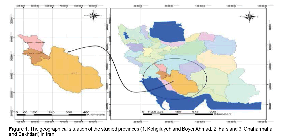
Studied regions consisted of three provinces including Kohgiluyeh and Bouyer Ahmad, Fars and Chaharmahal and Bakhtiari. Kohgiluyeh and Bouyer Ahmad province is located southwest of Iran between (29° 52' to 31° 26' N, 49° 55' to 51° 53"E); Fars province is located in south of Iran (27° 3' to 31° 40' N, 50° 36' to 55° 35"E); Chaharmahal and Bakhtiari province is among mountainous areas of the central plateau of Iran (31° 9' to 32° 38' N, 49° 30' to 51° 26'E) (Figure 1).
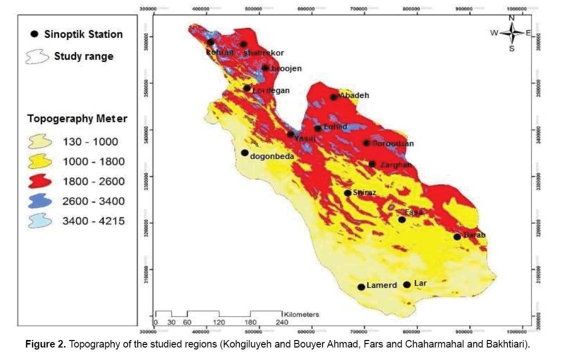
As shown in Figure 2, the minimum height is related to Lar, Lamerd and Dogonbadan stations and the maximum height is associated with Koohrang, Lordegan, Shahrekord, Yasuj stations.
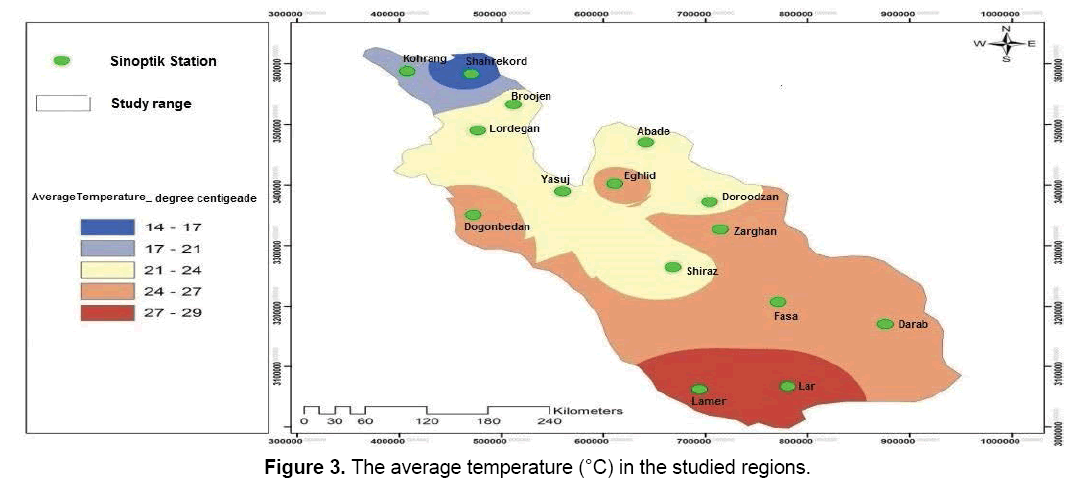
As noted in Figure 3, the minimum temperature is related to Koohrang station in Chaharmahal and Bakhtiari and the maximum temperature is associated with Lar and Lamerd stations.
2.1 Thermal thresholds
Plants need three thermal thresholds of minimum, maximum and optimum temperatures called main heating degrees or main points for their biological activity [8].
The base temperature: Minimum temperature below which no growth occurs. The base temperature differs in terms of plant species and growth stages. For example, the base temperature for wheat and barley is 3-4.5°C [9].
Optimum temperature: As temperature of thermal base increases, plant growth gradually increases and maximum growth occurs at a certain temperature, varying in terms of plant species and growth stage which is called optimum temperature. Optimum temperatures for wheat and barley are 25°C and 20°C, respectively.
Maximum temperature: As temperature gradually increases and passes the desired temperature, plant growth gradually decreases and growth completely stops after a maximum temperature which is different in terms of plant species and growth stage. The mentioned threshold is called maximum plant species temperature. Maximum temperature for wheat is 30- 32°C and for barely is 38-40°C. At temperatures higher and lower than the optimum range, pregermination metabolic activity is reduced [10]. Lower temperature prevents germination and results in seed decay. Temperature above the optimum temperature may cause seed recession.
Thermal Units: It is stated for the first time in 1735 that the total daily temperature of the air in the shade between two stages of plant growth is constant for a particular species of plant. The concept of thermal units or degrees day represents the relationship between plant growth and the air temperature [11]. The concept indicates a direct linear relationship between growth and air temperature. Degrees day is the mean deviation of daily temperature from a minimum thermal threshold. It is the minimum threshold temperature below which no growth happens. Degrees day is calculated by subtracting the base temperature from the average daily temperature [12]. As the factors and interactions that alter the thermal units are very complicated in nonirrigated conditions, so the use of a thermal unit which has been calculated for a certain area and season is hardly acceptable for different regions and seasons. Thus, in the present circumstances there is no choice but to conduct experiments in each area and every season. The use of soil temperature rather than air temperature makes thermal units more accurate when the plant is out of the soil, because at this stage the plant is mostly influenced by soil temperature.
Total of annual thermal units: Thermal units include from the beginning of rainfall equal to or more than 5 mm in autumn to the end of June. This scenario also includes the amount of thermal units of the air, soil surface and a 5 cm depth of soil.
Total thermal units of autumn: These include total thermal units from the date of the start of precipitation equal to or more than 5 mm to the beginning of the winter for the air, soil surface and 5cm depth of soil.
The total thermal units into separate stages: These include total thermal units for each of the stages from the date of planting to maturity of the product for the air, soil surface and 5 cm depth of soil [12].
2.2 Kohgiluyeh and Bouyer Ahmad province
Regarding the geographical situation and distribution of Zagros Mountains, as we move from the northeast towards the southeast, mountains height, amount of atmospheric fallout, and humidity are reduced. Natural distribution of heights and low-altitude areas of 500 m on the side of one of the peaks of Iran (Dena) have created dual temperate and tropical climactic features. The city of Bouyer Ahmad and the studied area are located in the temperate division (Kargar, 2008: 47-46). The results of seasonal rainfall changes show that the most annual rainfall of Yasuj was reported in winter as much as 556 mm of rainfall contribution corresponding to 50-60%, in the second month of the autumn as much as 317mm of rainfall corresponding to 25-30%, the third month of the spring as much as 90mm of rainfall with about 10% of total annual rainfall (Meteorology Organization of Kohgiluyeh and Bouyer Ahmad). Due to the establishment of Subtropical High Pressure over Iran and especially Kohgiluyeh and Bouyer Ahmad in the summer which prevents any significant air movement, rainfall is less than 5 mm [9].
2.3 Fars province
Average amount of monthly rainfall in the area is 45 to 48 mm which its maximum is 184.20 mm in December and its minimum is 0 mm in July, October, and November.
2.4 Chaharmahal and Bakhtiari province
Atmospheric fallout in this province begins in October and reaches its peak in December and then is reduced until April. On average, 19% of rainfall occurs in December. Percent of monthly rainfall from November to April constitutes over 90% of annual rainfall and less than 10% of annual rainfall from May to September. West highlands with 1600 mm of annual rainfall are the rainiest regions in the province. Sabz Kooh highlands with average rainfall of 1400 mm and southwest highlands with 900 mm of rainfall are among the rainy regions in the province. Eastern and northeast regions with 250 to 300 mm of annual rainfall are the least rainy regions in the province. Average annual rainfall of the province is about 560 mm. Due to the existence of mountainous regions in the province and regarding the fact that air temperature is influenced by each region height, there are different thermal climates in the province.
2.5 Agricultural status of studied provinces (Kohgiluyeh and Boyer Ahmad, Fars and Chaharmahal and Bakhtiari)
On the average, acreage under wheat cultivation in Kohgiluyeh and Bouyer Ahmad, Chaharmahal and Bakhtiari and Fars has been increased from almost 130000 ha in 1996 to 112000 ha in 2011. Growth acceleration of area under cereals cultivation has had higher intensity during the 2001-2006 study period. Generally, 25.2% has been added to acreage under cereals cultivation during the fifteen-year study period, whereas total cultivated acreage of crops in Kohgiluyeh and Bouyer Ahmad has remained unchanged (Agriculture Organization of Kohgiluyeh and Bouyer Ahmad).
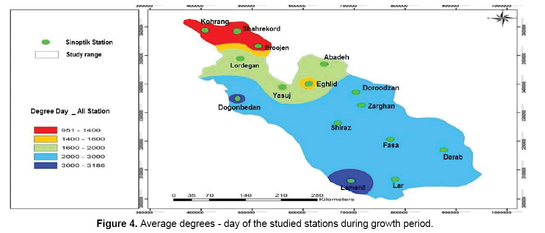
Based on Figure 4, average degree-day of all studied stations is observed. Koohrang, Shahrekord, Borujen stations had between 950 to 1400 degree-days, Eghlid station had between 1400 to 1600 degree-days, Lordegan, Abadeh and Yasouj stations had between 1600 to 2000 degree-days, Darab, Lar, Fasa, Shiraz, Zarghan and Doroodzan stations had between 2000 to 3000 degree-days and Dogonbadan and Lamerd stations had between 3000 to 3186 degree-days.
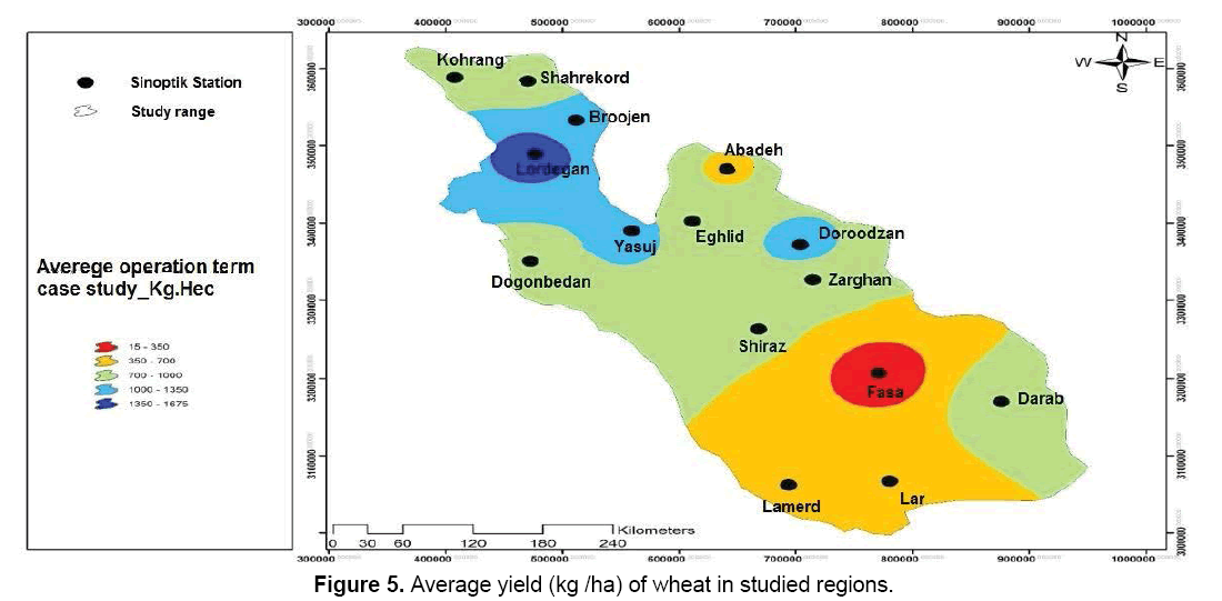
As noted in Figure 5, the highest yield belongs to Lordegan in Chaharmahal and Bakhtiari and the least yield belongs to Fasa in Fars province.
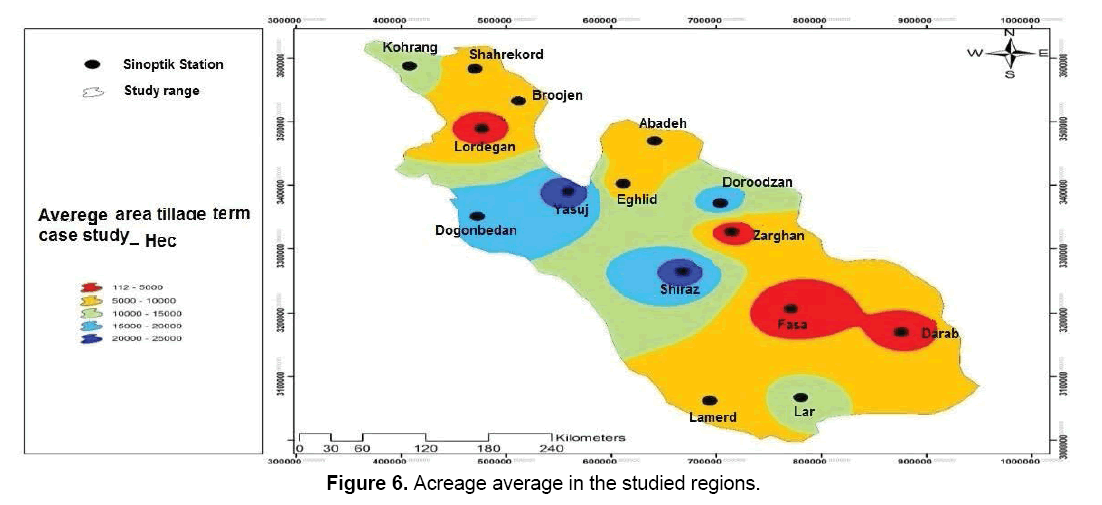
As observed in Figure 6, the maximum average of cultivated acreage was related to Yasouj and Shiraz stations and the minimum average of cultivated acreage is related to Lamerd, Darab and Fasa.
3. Results and Discussion
The average annual rainfall in the three provinces over a twenty-year of common statistical period (1995-2015) is equal to 299.94 mm.
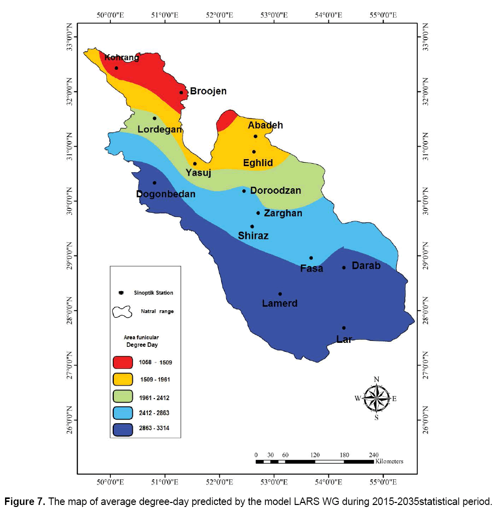
In Figure 7, the map of average degree-day predicted by the model LARS WG is inserted for all stations of the studied regions during 2015-2035 statistical periods. Data show that the degree-day of studied regions has been increased from the north to the south. The maximum degree-day is associated with southern stations and the minimum day-degree is associated with northern stations including Borujen and Koohrang.
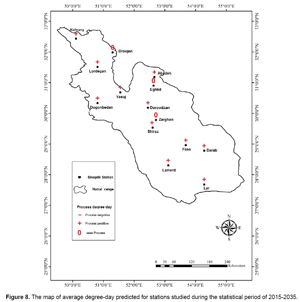
As shown in Figure 8, most stations have had an increasing trend and only 3 stations including Eghlid, Zarghan and Borujen have not shown any trend.
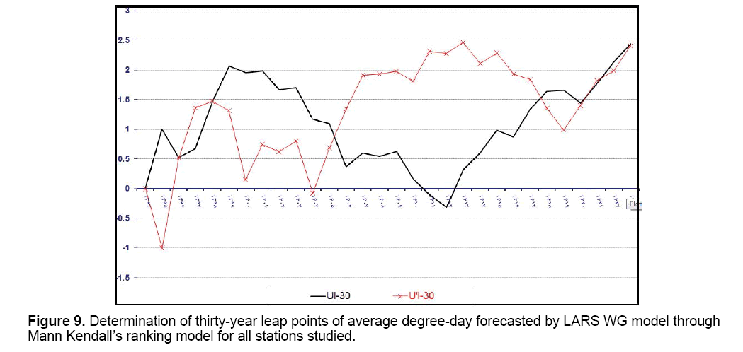
The results from Figure 9 showed that a sudden change occurred in behavior changes of U and U' components related to degree-days associated with weather stations forecasted by LARS WG model in 2025 and it had an increasing positive trend (significant trend). In general, the trend of future degree-day of the studied region is meaningful and increasing.
Temperature changes of the three provinces (during 2004-1982) have had a trend and the average minimum temperature (10-13°C) belongs to Chaharmahal and Bakhtiari and the highest temperature is related to the southern Fars (22-25°C). Regarding minimum temperature, the minimum temperature belongs to Saman station in Chaharmahal and Bakhtiari and the maximum temperature belongs to Emamzadeh Jafar in Kohgiluyeh and Bouyer Ahmad, Iran. Regarding maximum temperature, the highest temperature belongs to Lar station in Fars province and the minimum temperature belongs to Koohrang station in Chaharmahal and Bakhtiari. The highest degree-day is related to Lamerd station with 3186°c and the minimum degree-day is related to Koohrang station in Chaharmah and Bakhtiari with 951°C. Moving from the northwest to the southeast showed that average degree-day has been increased for a twenty-year of statistical period. Accordingly, Shahrekord and Koohrang stations have the minimum degree-days and Dogonbadan and Lamerd stations have the highest average degreeday. Moving from the northwest to the southeast showed that average degree-day of autumn has been increased during the twenty-year of statistical period. Accordingly, Shahrekord, Borujen and Koohrang stations had the minimum degree-days and Dogonbadan, Darab, Lar and Lamerd stations had the highest average degree-day in autumn. As the minimum degree-day of 400-600°C should occur for non-irrigated wheat in autumn, it can be said that this condition has been occurred in all stations except for Borujen, Shahrekord and Koohrang. Based on the study of changes of U and U ' components related to degree-day forecasted by LARS WG model associated with weather stations, it was concluded that a sudden change occurred in 2025 and it had an increasing positive trend (a significant trend). Generally, the trend of future degree-day of the studied regions is meaningful and increasing. Statistical period of 2015-2035 forecasted using LARS WG and Mann Kendall models shows the map of average degree-day forecasted using the model for all the studied stations. Based on the findings, degree- day of the studied regions is increased from the north to the south. The maximum degree-day is related to southern stations of studied regions and the minimum degree-day is related to northern stations including Borujen and Koohrang. Findings of the study showed that most stations have had an increasing trend and only three stations of Eghlid, Zarghan and Borujen did not show any trend.
4. Conclusion
In general, according to the analysis conducted on climate and rainfed wheat in three provinces including Kohgiluyeh and Bouyer Ahmad, Fars and Chaharmahal and Bakhtiari following results were obtained: 1: With regard to the average degree-day during the 20 years statistical period, Lamerd station with 3186 degrees has the maximum degree-day and Koohrang station with 950 has the minimum degree-day. 2: Regarding wheat production during the 20 years statistical period, 2003-2004 crop years with 110400 kg has allocated to itself the maximum level. 3: Regarding the yield of rainfed wheat during the twenty-year period, the crop year 2007-2008 with 2400 kg/ha has allocated to itself the maximum level. 4: A comparative study of maps of rainfed wheat with degree-day and rainfall show that parameters of rainfed wheat yield are highly relevant to amount of rainfall. This means that in most years these two parameters have had direct relationships and as the amount of rainfall increases the level of wheat yield also increases. 5: A comparative study of maps of rainfed wheat production with degree-day and rainfall show that parameters of wheat production are highly relevant to temperature or degree-day. In other words, in most years these two parameters have had direct relationships and as degree-day increases the level of non-irrigated wheat production also increases. 6: In the study of routing temperature and rainfall in the studied stations, it was concluded that all stations studied have had their own trend and do not follow a certain trend.
References
- Pal RK, Rao MNN, Murty NS. (2013). Agro-meteorological indices to predict plant stages and yield of wheat for foot hills of Western Himalayas. Int J Agric Food Sci Technol. 4: 909-914.
- Clafferty B. (2000). Ensuring food security in Egypt, food subsidy, income generation and market reform. Food Pol. 25: 219-224.
- Da-Silva LMV, Pinell P. (2014). The genesis of collective health in Brazil. Sociol Health Illn. 36: 432-446.
- Ronald P. (2011). Plant genetics, sustainable agriculture and global food security. Genetics. 188: 11-20.
- Slafer GA, Rawson HM. (1995). Base and optimum temperatures vary with genotype and stage of development in wheat. Plant Cell Environ. 18: 671-679.
- Kazemi MH, Talebi-Chaichi P, Shakiba MR, et al. (2001). Biological responses of Russian wheat aphid, Diuraphis noxia (Mordvilko) (Homoptera: Aphididae) to different wheat varieties. J Agric Sci Technol. 3: 249-255.
- Fischer G, Shah M, Tubiello FN, et al. (2005). Socioeconomic and climate change impacts on agriculture: An integrated assessment. Philos Trans R Soc Lond B Biol Sci. 360: 1990-2080.
- Mahan JR, Burke JJ, Wanjura DF, et al. (2005). Determination of temperature and time thresholds for BIOTIC irrigation of peanut on the southern high plains of Texas.Irrigation Science. 23: 145-152.
- Zarenistanak M, Dhorde AG, Kripalani RH. (2014). Temperature analysis over southwest Iran: Trends and projections. Theor Appl Climatol. 116: 103-117.
- Leiblein-Wild MC, Kaviani R, Tackenberg O. (2014). Germination and seedling frost tolerance differ between the native and invasive range in common ragweed. Oecologia. 174: 739-750.
- Ali MH, Hoque MR, Hassan AA, et al. (2004). Photo-thermal unit requirement of wheat under different levels of irrigation. Journal of Bangladesh Agriculture University. 2: 351-360.
- Rahimi D, Khademi S, Nadafi S. (2014). Estimation of evaporation and transpiration of wheat plant in Zaraghan station using CROPWAT model. Int J Adv Biol Biomed Res. 2: 1362-1370.

Open Access Journals
- Aquaculture & Veterinary Science
- Chemistry & Chemical Sciences
- Clinical Sciences
- Engineering
- General Science
- Genetics & Molecular Biology
- Health Care & Nursing
- Immunology & Microbiology
- Materials Science
- Mathematics & Physics
- Medical Sciences
- Neurology & Psychiatry
- Oncology & Cancer Science
- Pharmaceutical Sciences
